We lost half of the science team in Saipan. The fun work of surveying fish populations is over so the AUV, BotCam and BRUV teams have headed for home. A tsunami at sea is not felt by ships, but the tsunami warning came while we were still at the dock. We were alert and ready to depart, but fortunately for us and the entire Pacific, the tsunami didn’t materialize.
We are now mapping the seafloor around the island of Farallon de Mendinilla. The ship goes back and forth over a given area much like “mowing the lawn,” in fact they frequently refer to it that way. We will be doing this for about 12 days. The data comes into the ship’s computers and the clean-up work begins. Two or three people work at the computers day and night cleaning the data. The sonar sends out 3 or 4 pings per second. Each ping has 101 beams. Every beam of the multibeam sonar makes a dot on the computer screen. Some of the dots lie outside the target area and must be zapped. This is time consuming, tedious work. I am learning and I cleaned three paths yesterday. I am incredibly slow and have to stop frequently to get additional instructions. (That's me on the left, hard at work.)


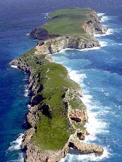
Right: The BRIDGE of Farallon de Mendinilla (or is it a tunnel? or a cave? )
The island is small (1.6 miles long by 0.25 mile wide) with only grass and shrubs―not even one coconut palm. There are a lot of birds: frigates, boobies, terns, and other species. We’ve seen whales on three occasions. The ones that were close enough to identify were humpback whales.

The BRIDGE of the Oscar Elton Sette is where the officers drive the ship, plot courses, handle navigational concerns and communications. I’ve had two tours of the bridge and am amazed by the electronics and complexity of each system. Rather than a description, I’ll just give you a few pictures.
 Eric showing one of the ship's many charts.

Right: The steering wheel is considerable smaller than I expected.
 Chart table used for plotting the course. GPS is also used, but charts are kept in case the power fails.

Right: The iridium phone works via satellite. The crew can use it for personal calls during non-business hours (East Coast to Hawaii). That doesn't leave much time but it is also available on weekends.


Right: This sign on the bridge lets the skipper know that there are fishing lines off the stern.
 be doing this for about 12 days. The data comes into the ship’s computers and the clean-up work begins. Two or three people work at the computers day and night cleaning the data. The sonar sends out 3 or 4 pings per second. Each ping has 101 beams. Every beam of the multibeam sonar makes a dot on the computer screen. Some of the dots lie outside the target area and must be zapped. This is time consuming, tedious work. I am learning and I cleaned three paths yesterday. I am incredibly slow and have to stop frequently to get additional instructions. (That's me on the left, hard at work.)

Right: The BRIDGE of Farallon de Mendinilla (or is it a tunnel? or a cave? )
The island is small (1.6 miles long by 0.25 mile wide) with only grass and shrubs―not even one coconut palm. There are a lot of birds: frigates, boobies, terns, and other species. We’ve seen whales on three occasions. The ones that were close enough to identify were humpback whales.

The BRIDGE of the Oscar Elton Sette is where the officers drive the ship, plot courses, handle navigational concerns and communications. I’ve had two tours of the bridge and am amazed by the electronics and complexity of each system. Rather than a description, I’ll just give you a few pictures.
 Eric showing one of the ship's many charts.
Right: The steering wheel is considerable smaller than I expected.
Chart table used for plotting the course. GPS is also used, but charts are kept in case the power fails. Right: The iridium phone works via satellite. The crew can use it for personal calls during non-business hours (East Coast to Hawaii). That doesn't leave much time but it is also available on weekends.

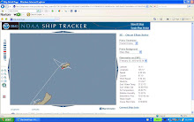
Left: Mike is reflected in the radar.
The red triangle just right of center
is Farallon de Mendinilla.

Right: This sign on the bridge lets the skipper know that there are fishing lines off the stern.


14 comments:
Wass up Ms. Tatreau...
So were you guys at now!
Hows the trip so Far? Great i hope.
I was wondering if you guys found any new species of aquatic life yet?
Jose-3
Hi Jose,
We are going back and forth & back and forth & …. at Farallon de Mendinilla. We will be doing this for days as we use the multibeam sonar to map the seafloor. It can get a bit repetitious but we have been seeing whales every day. We have not been looking for new species of fish. We have been using cameras to survey fish populations. If you have watched the videos, you will know that it would be unlikely to spot a new species using this type of equipment. Not impossible, but it hasn't happened on this trip.
Oh, too bad we didn't have the chance to say goodbye to the other science team. Keep up the good work Ms. Tatreau. You're really working very hard. The bridge indeed looks like a tunnel to me also. It is such a nice view. Yeah, the steering wheel is really small compared to the ones I've seen on T.V. It's amazing to see those electronic devices, the phone, the radar, etc. I find it funny when I read "Dolphins in the Jacuzzi," because people are usually the one who uses jacuzzi, hehe.
Ritzmar-5
Hi Ritz,
Even though there is little vegetation on Farallon de Mendinilla, it is a beautiful island with striking cliffs and, of course, the “window” to the other side. I was on the back deck a few days into the trip when I heard the announcement, “Take the dolphins out of the Jacuzzi.” It took me a minute to comprehend.
Hi Ms. Tatreau! I finally convinced myself to make a comment. It must be fun and stressing considering how long it takes to get the pictures. So how many hours/days did the AUV spend in the water so far? And did you get to see the pictures yet?
Peter-3
Hi Peter,
All of your questions are answered on the blog. Take some time to read it. The AUV was in the water at total of 25 hours during 7 nighttime trips. Some of the pictures are posted on the blog under the page titled, “AUV Photos from Galvez Bank.” I did see the 13 pictures that were sent wirelessly. They were random shots of the seafloor. That technology is still in its infancy.
all this stuff seems like so much fun.
but i don't get when you say 'we lost half the science team'
what does that mean??
jaceth - 2
Hi Jaceth,
They are not lost at sea :) Elizabeth got off the ship in Rota and the others left while we were in Saipan. They were working the fish surveys and that work is done for now. We did get some new people: a NOAA officer, 2 members of the Coast Guard and an internet specialist.
Hey Ms. Tatreau,
Gosh you've been gone too long!! Are you having just as much fun mapping the sea floor than watching the fish? Anyways, i was just wondering the entire distance that the sonar covers everytime it pings. Also, how far out at sea are you mapping out from the island? And you mentioned that data gets 'cleaned' at night...what exactly does that mean and how long does it normally take?
+Tito-5
Hi Tito,
Sorry you had to ask your question twice. I am a little behind in responding. I don’t have too many duties but the time seems to fly. Actually the fish work was more fun than the mapping because there was more action. With the mapping, there is not much excitement. Maybe we will find an unknown seamount. It’s possible. Much of this area has only been surveyed using sonar by ships that are in transit. We are using their data to find shallow areas for further mapping. We finished mapping Farallon de Mendinilla. We mapped from the island out 10 to 12 miles focusing on the shallow area to a depth of about 100 meters. After that it drops rapidly to about 1000 meters. We found the area we mapped to be very flat.
The deeper the water, the greater distance the pings cover. At a depth of 90 meters the pings record the depth to a width of 250 meters. The data in the center is much more accurate than the data at the ends. That’s what we have to “clean.” Dots that are widely spaced are removed. The experts are fast. It took me 2 hours to clean my first megabyte of data. I am faster now but still slow in comparison. It takes the ship about 20 minutes to collect one megabyte of data.
Hi Ms.Tatreau Its good to see you having fun! I miss you so much, your class is not the same without you. I can't wait for you to come back. Anyways since no one commented on this blog, I'll comment it. What kind of line is used to hold the camera? Is it a ridge line or flexible line?
Toby Cruz-5
Hi Toby,
I miss all of you too. As much fun as it is being at sea, I look forward to returning to the classroom. The line that holds the BotCams and the BRUVs is polypropylene line (rope). It is a popular line for use on ships. It has three stands and is easy to splice. It has a high strength and low stretch. It is buoyant and bright yellow for visibility. It is resistant to most chemicals; it is not biodegradable but it does deteriorate after long exposure to the sun. If we lose it over the side, this line will cause the same problems as plastics in the ocean.
Ms. Tatreau,
how've you been?! My comment is too ask what the difference is between a multibeam and a side scan sonar. Which one is better for seafloor mapping?
thanks,
josh-3
Hi Josh,
The multibeam sonar is used for mapping the seafloor. The data from the multibeam are the depths. The side scan sonar is used to estimate the hardness and roughness of the seafloor. The size and character of the electronic signal gives clues about the composition of the seafloor (hard/soft, rough/smooth). The multibeam does give some information about the seafloor in data that are called back scatter. You can read more about this on the page called Multibeam Sonar.
Hey Ms. Tatreau,
Wow, you seem to have a lot since you first set out. :] I'm glad to learn you guys wouldn't have felt the tsunami if you guys were still out at sea, that's what i was concerned about. Anyways, I was wondering how many times you're going to be doing the clean-up work if its only two or three people working day and night? Also, how much workers are left on the ship since leaving Saipan?
Angelfish -5
Hi Angelfish,
When the tsunami warning came, I knew we would be OK. I was more concerned about everyone on Guam and my friends in Hawaii. The clean-up work on the data from the multibeam sonar will continue until we return to Guam. The multibeam gathers about one megabyte of data every 20 minutes. It takes at least that long, generally longer, to delete the wayward beams (killing dots on the computer screen). I said that there are 2 or 3 people working day and night at this project, but we take frequent breaks because the work is so monotonous. The map-makers also spend time assembling the data into usable map formats. The science team is down to about 9, but the ship’s crew is still onboard. An internet expert joined us in Saipan and he is working on the maps. We were also joined by 2 members of the Coast Guard.
What is the most interesting thing you have found or what are you looking forward to finding with the 10 cameras? -Coleen
Hi Coleen,
In the next couple of days, I will post Steve’s article on the BRUVs that will answer this question in detail. If you watch the 2 video clips on this blog, you will see some of the most interesting fish action. Steve, Sparky, Mary and Jake are looking forward to using their data to analyze fish populations without having to catch the fish.
Hi Jas,
The people who left us in Saipan were members of the science team. Their work involved the AUV, BotCams & BRUVs and that part of the research is over. The entire ship’s crew is still with us―we need them to run the ship.
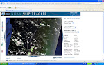
I have a variety of maps posted on this blog. The maps showing the ship’s location are from the NOAA ship tracker (you can find a link to that website on the right side of the blog’s home page). The bathymetric (seafloor) maps of Galvez Bank were made here on the ship with the data collected from the multibeam sonar. It really impressive what can be done with today’s technology.
I'm glad to see you guys are safe and having fun! :)
I think that Farallon de Mendinilla is a beautiful island, even though there are no humans living on it.
The picture of the "Bridge" looks like a small bridge, so it looks like a tunnel to me.
I would be really neat to learn how to use that data computer and clean those dots that are outside the target. It does look time consuming, but its all okay to learn more.
You look like you're having fun doing it Ms. Tatreau. :) Good job!
While you were there at Farallon de Mendinilla, did you see any cool species of fish or creatures that would amaze me.
TASHA - 6
Hi Tasha,
Yes, Farallon de Mendinilla is a lovely little island. It’s a shame that the military has to use it for bombing practice. We spent our time at the island mapping the seafloor so we didn’t see many fish. We did see a variety of species of birds and for 3 days we saw humpback whales.
Hello,
I am an exnavy seabee i help build a 50ft.observation tower on Farallon. This was back in 1985.It took 8 builders & 4 steelworkers to complete the job. All the steel was pre fab in Guam then loaded on the USS NIAGARA FALLS then air dropped. I was curious if anyone has photos of the tower or does it even exist?
Hi,
I’ve asked around and no one onboard knows of a tower on Farallon de Mendinilla. We were fairly close to the island and didn’t see anything that looked like a tower. I will keep asking and if I discover any new information, I’ll post it on this page. You can e-mail me at greensharkfeet@gmail.com and we can stay in touch when this cruise is over in case I learn more.
Hi again to the ex-Navy SeaBee asking about the tower on Farallon de Mendinilla,
I’ve talked to everyone who spent time on the bridge while we were working around the island. They all agree that there is no tower. If not rust and/or typhoons, then it would have been a great target when the military started bombing the island for practice exercises. The military still drops bombs with regularity.
The water looks beautiful in the pictures taken and posted. The "Bridge" looks like a tunnel to me. I am curious to know where the humpback whales were found, I have yet to see a whale, so that caught my attention when you mentioned you saw them.
Coleen-2
Hi Coleen,
The humpback whales were around the island of Farallon de Mendinilla. I looked on-line and found an article that said there was a small population there. Humpback whales are known for their long migrations from their feeding grounds to the places where they mate and give birth. It would be fun to learn the migration patterns of these whales.
Post a Comment