 This is day #3 working off-shore of the beautiful island of Rota. While working at Galvez Bank we could see Guam at a distance of about 14 miles, but it was just a big bump on the horizon. While working in this location, we are close to shore and can enjoy the view of tropical vegetation, white sandy beaches and carbonate cliffs. The work in Rota has included BRUVs, multibeam and the AUV.
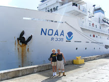
Linda, Viv and Tony with Rota in the background.
 The AUV work has gone smoothly. Launching occurs each evening about 8:00 with recovery at midnight. The AUV has 2 cameras, one facing downward to photograph the geography and one facing forward for better fish identification (it’s difficult to identify a fish from the top, looking down). At night the AUV takes only still photographs. A strobe illuminates the scene every 5 seconds and the cameras shoot in synchronicity. A 4-hour trip produces more than 2,500 photographs with each camera. Processing that many pictures is a time consuming job. The AUV also has a CTD and records data for future analysis. Chirs (see Meet the Science Team) is working on a program that will allow the AUV to send pictures to the ship in real time. To date, this has only been accomplished when a ship is directly over the AUV. Chris is very close to success―maybe tonight.
  Linda cutting bait for the BRUV bait bags.
 BRUV boys loaded up and ready g0.
 The BRUV team says this trip has been the easiest BRUV work ever. In the next breath, they say this trip has been the most difficult BRUV work ever. The easiest―Galvez Bank where launch and recovery were from the ship. Launching was accomplished by simply tossing them off the stern. They were brought back aboard using an electric winch. The most difficult―Rota where the work is close to shore and the ship can’t go. Now they are using a small boat. With all the equipment piled on the boat, there is barely space for 3 people―the driver and 2 to handle the BRUVs. They have 4 BRUVs nestled on the little boat along with all the associated lines and buoys . Add bait, bait bags, lunch and drink and there is not much working area. Once rigged, the BRUVs are tossed over the side in 100 to 150 feet of water. Recovery is accomplished using a hand winch―at 150 feet deep, that is a lot of manual turns of the handle. Difficult as it may be, yesterday they managed 13 BRUV drops in 8 hours.
OK, every entry in this blog has been mostly science. For me, that’s the greatest fun. For the next entry, I’ll try for some of the non-science fun onboard a ship.
OK, every entry in this blog has been mostly science. For me, that’s the greatest fun. For the next entry, I’ll try for some of the non-science fun onboard a ship.


23 comments:
What's up, Ms. Tatreau?! Boy do I miss you! I would really like to know who is in charge of checking the 2,500 pictures that the AUV takes. That seems like a very stressful job...Chives and I created a great display board! There is zooxanthellae everywhere!Hope to hear from you soon.
Elyssa(Beyonce)-5
Hi Beyonce,
Her name is Erica (see the page titled, “Meet the Science Team”). She has a really interesting job when she isn’t working with the AUV―she spends a lot of time at sea counting fish on the West Coast of the United States. Analyzing the pictures from the AUV is not stressful, but very time consuming and sometimes a bit repetitious. I look forward to seeing your display where zooxanthellae ARE everywhere (zooxanthellae = plural). I miss all of you too.
Hey Ms. Tatreau :]
It says in this blog that launching starts at 8:00pm... I was wondering why you guys started work at that time? Is there a specific reason for this?
Also, who's job is it to process all those pictures from the AUVs?
Hope you're having fun. Can't wait for more updates! :]
Angel -5
Hi Angelfish,
The AUV is launched at 8:00 P.M. because the scientists want to study the fish that are active at night. Waiting until 8:00 allows time for the transition when the diurnal fish go to sleep and the nocturnal fish come out to hunt. Processing photos? See my answer to Beyonce’s question on this same page, just above yours.
hey!linda!
i was wondering what makes the spot where you place the camaras an ideal spot, also how lond do you leave it there?
Hi Keving,
The camera locations are picked using the bathymetric maps that are made using the multibeam sonar data gathered during the expedition and processed onboard. The maps of Galvez Bank were completely new this trip. The maps of Rota are an improved edition as there had already been some mapping done in this area. The maps show depth and roughness. The roughness can be an indication of coral and that’s where they want to place the cameras. It doesn’t always work―sometimes the cameras still end up on the sand flats. The cameras are left for an hour because that’s how much video the memory card can hold. Then they pick up the BREV, change the memory cards, put new bait in the bag and set it down in a new location. Yesterday, in 8 hours, they did 16 drops. That’s a big job working from a small boat.
This is my first time to see Rota, even in picture. Really nice view and can be a cool background. A lot of good information on AUV page. It could have been better if more than one small boat are provided because the small boat is really small. I can't wait for the non-science topic, hehe.
Ritzmar-5
Hi Ritz,
Put Rota on your list of places to visit. This trip, I am only seeing it from the ship but I have been a tourist on Rota several times and it’s a lovely island. Very quiet and peaceful, and there are so few cars that every driver waves to every other driver. One small boat doesn’t seem like much when working with the BRUVs, but read my comment to Keving posted just above this one. You will be impressed by what they can accomplish.
Wow, thats a lot of pictures... what do you guys end up doing with the 2,500 pics per camera?
-Jhorge Gonzales -1
Hi Jhorge,
I took your question to the AUV team. They laughed because that is the most common question. The number of pictures for this cruise alone totals 26,093. One team will use the pictures to analyze fish populations―that being the purpose of this expedition. Other groups will use the pictures to map bottom structure (coral coverage, sand, algae, etc.). The videos will be archived and made available, world-wide, to other groups of scientists, students and anyone else who needs them for any type of project.
Hi Ms. Tatreau,
I can tell by the pictures and information you are displaying that you are having fun. I was going to ask what was the abbreviation AUV meant, but I read and looked around and I figured out what it was. =)It means "Autonomous Underwater Vehicles", but of course you knew that ever since. haha. I'm sort of lost like I usually am though, but here's my question, what does BRUV mean? I'm sort of surprised that they, the BRUV team had to use a small boat to set the equipment out. (I think I read that part correctly). Man Ms. Tatreau it's hard not having you around to lecture us and help us understand the lessons given. Well that's all for now. Hope to hear from you =) We miss ya and be safe on the rest of the trip =)See ya soon!!
CHIVES-5
Hi Chives,
The answer to your question comes from one of my first posts:
“The BotCam (bottom camera bait station) has an anchor and floatation that will keep it a few feet above the bottom. The BRUVs (Baited Remote Underwater Video) will sit directly on the bottom.” Each of these systems has two cameras that act in stereo and allow the researchers to determine the size of the fish. During our time at Galvez Bank the camera arrays were set from the ship. Here at Rota, they are working close to shore and must use the small boat.
Hey Guys, hows the water?
Anyways i was wondering how long are the BRUVs tossed over the boat. How long do they stay 100-150 ft of water. Tell the BRUV guys, that they are awesome. I mean a hand winch and 13 BRUVs in 8 hours. Thats just crazy... Mar-5
Hi Mar,
Your question is the same as Keving’s. I replied, “The cameras are left for an hour because that’s how much video the memory card can hold. Then they pick up the BREV, change the memory cards, put new bait in the bag and set it down in a new location.” I though 13 was incredible, yesterday they did 16. I have been chopping the bait before they go. Day one, I chopped one box of bait, day 2 it was 1.5 boxes, this morning 2 full boxes. The seas have been really calm so they are planning a big day.
Well Linda...I mean Mis Tatreau...Science is FUN! without science what fun would there be??? lol...hmm yeah I guess you should put up the nonscience fun though. I mean it is still part of your trip!? and of course we would like to know about it! haha Get back to your real work Linda!...i mean Mis Tatreau! aha we need to practice for the fishbowl!
Kristopher Laguana
Hi Kris,
I wish I was home for FishBowl practices. I hope you are cramming your brain full of facts from the study guide. We will still have a month to study when I return. I wonder if there will be any questions from Fish 250, like, "What is a BRUV?" :)
What happens if a fish hits the camera, or if one of the cameras stop working? Has it happened yet? The blog says "they managed 13 BRUV drops in 8 hours." Does that mean they put the BRUVs at the site and then come back, or do they stay at the site until the cameras get enough footage and then come back with the BRUV?
Mary-1
Hi Mary,
The small boat carries 4 BRUVs nested together. They take up most of the space in the small boat. Steve & Sparky plan where to place them ahead of time. They have a GPS to find the drop points. By the time they drop #4, it’s time to pick up #1. So it goes for 8 hours. Yesterday they did 16 drops. The seas have been really calm and that makes it easier. The memory cards in the cameras record video for an hour. If the BRUV stays on the bottom longer, it is not a problem. The cameras are attached securely so it is unlikely that a fish could hit it hard enough to do any damage. The funniest incident occurred when, shortly after the BRUV reached the bottom, a big fish came up to the bait bag, ripped it off and carried it away. The cameras have all worked fine during this trip. Occasionally a BRUV lands in a sandy area with few fish and a couple of the BRUVs landed upside down. The BRUV team completed 125 drops this trip and in only one instance did the camera not record the action.
Ms. Tatreau!
It looks like your having a lot of fun. I was wondering, what does BRUV stand for? How far down can it go?
Nicole-3
Hi Nicole,
The answer to your question comes from one of my first posts:
“The BotCam (bottom camera bait station) has an anchor and floatation that will keep it a few feet above the bottom. The BRUVs (Baited Remote Underwater Video) will sit directly on the bottom.” The BotCams were designed for deep water and can go to a depth of 3,300 feet. The BRUVs are much less expensive and the ones being used on this trip can go to a depth of 1,600 feet. The maximum depth depends on the quality of the cameras―the stronger the housing, the deeper they can go.
Hi Ms. Tatreau & crew,
First off, I hope is well.(:
I read that the AUV was not communicating with the ship. Was the problem diagnosed? If so, was it able to be fixed? Are there extra parts to the AUV (like a car) that can be taken off and replaced, or do you have to stop using that particular AUV all together?
Can't wait to see the pictures!
Jas-3
Hi Jasmin,
When the AUV is not communicating with the ship from the beginning, the trip is aborted. Sometimes there are problems during the dive, but if communications are not reestablished, the AUV surfaces on its own after a predetermined period of time. The team did carry a second AUV for this trip which was used for parts to keep the primary AUV in running condition. The work accomplished by the AUV on this trip was so successful that a short trip scheduled for this evening has been cancelled.
Hi Ms. Tatreau ! I read that on a 4 hour trip , the AUV can produce more than 2,500 photos . I would like to know more about how the geography is looking down there and if you and the team have come across anything unusual using the AUV and the BRUV's . I would also like to know how the fish populations are doing in the areas you have conducted AUV and BRUV work .
Jeremy Garrido-1
Hi Jeremy,
Look at the post of February 20th tilted, “Guppies.” You will see a bathymetric map of Galvez Bank. Color indicates depth from red being shallow to purple being the deepest. The AUV team used the maps to program the robot to cruise over coral where the most fish would be expected. They also tried to avoid steep slopes. Look at the page titled, “AUV Photos From Galvez Bank” to see some of the geography. The AUV team did not discover anything unusual but they did create a major highlight of the trip. I plan to write about it soon. The fish populations at Galvez Bank were more robust than anticipated while those at Rota had fewer fish than expected.
hi ms. tatreau how many kinds of fish are you studying?
Rachael-1
Hi Rachael,
The BRUV team estimates that they have seen over 200 species of fish on the videos. When they return to lab, they will spend days analyzing the videos to identify and count the fish and calculate their length.
Jeremy Cruz-1 GWHS
What does BRUV stand for?
Why is the monitoring up to 250 meters?
How long will the trip be?
Where do you get the bait to use on the trip?
Hi JC,
What’s a BRUV? That’s the most common question of the day. The answer to your question comes from one of my first posts: “The BotCam (bottom camera bait station) has an anchor and floatation that will keep it a few feet above the bottom. The BRUVs (Baited Remote Underwater Video) will sit directly on the bottom.” The scientists picked 250 meters because that is the depth at which they expected to find reeffishes and it’s a depth that works well for the equipment. The BRUVs can go to any depth. The BotCams were designed for deep water and the AUV can go to a depth of 2000 meters. On this trip, the BRUVs worked at depths from 30 to 60 meters. The AUV went to a depth of 364 meters. Baitfishes – see the answer to Mary’s question directly below this one.
Hi Ms. Tatreau,
For the bait, what kind of fish do you use? Is there a certain bait for certain kinds of fishes? How many bait bags are there on each of the BRUVs?
Hi Mary,
The baitfishes are Pacific saury, called sanma in Hawaii and usually marketed at mackerel pike. They were purchased, by the case, in Hawaii before the ship came to Guam. As you can see in the BRUV video, a lot of different species of fish were attracted to the bait. Each BRUV and BotCam has one bait bag situated about 3 feet in front of the two cameras.
Ms. Tatreau,
Wow, looks like you're having a lot of fun. That video was pretty cool. Have you gotten to try out Jason? Well come back soon because all this work is crazy. Rob-1
Hi Rob,
Yes, I sure am having fun. The weather is rough. Three people are seasick―luckily, I am not one of them. One person vomited in the stair well. I’m glad I wasn’t on clean-up duty. The ROV Jason is not on this trip, but I did get to experience Jason when we were studying the blue mud volcanoes in 2003. On this trip we used the AUV. Read about the exciting new AUV invention in the recent post titled, “Old Dog, New Trick.”
Hi Ms. Tatreau
This is Brandon Quintanilla from your 6th period class. I wanted to ask you are there any species of fish that are around Rota that aren't found around Guam?
Hi Brandon,
Nice to hear from you. We didn’t see any fish around Rota that are different from Guam fish. Since Rota is close to Guam and fish can have a long larval stage, the species are probably much the same on both islands.
Jeremy Cruz-1 GWHS
What are is the food like on the trip? Where are you going other than Rota?
Hi JC,
The food―most people gain weight on a trip like this. Three meals a day and we don’t have to lift a finger except to get the fork to the mouth. We clear the table, but we don’t have to wash our dishes. Did you take the food safety class? In the galley, they follow all the rules so, not only is the food excellent, there is no chance of food poisoning. Oh yes, dessert―fresh baked treats after every lunch and dinner. Fresh fruit is also available 24 hours a day. If that isn’t enough, there are snack foods always handy to tempt the appetite. The answer to your final question comes straight from the introduction to this blog, “…hopefully to include Galvez Bank, offshore slopes near Rota, and the banks of Farallon de Medinilla.”
Hafa adai Linda,
I would like to start this comment by saying...I MISS YOU however i hope your have as much fun as you can!:D
I was wondering about the National Oceanographic and Atmospheric Administration’s. Do they really only want to know about the fish population or do they just want to know If they can make a big profit if they fish there? Also i see that joyce maped out the sea floor of the Galvez Bank. How was the diving there? What was the most abundant species? Did you see any Nepoleon fish?
-Your favorite student Anthony-6 A.K.A "NONI".
Hi my favorite Anthony,
I miss all of you too, but I’m not complaining because I am having so much fun. NOAA is not out here to make a profit from fishing. The purpose of the trip is to find ways to assess fish populations without taking the fish. In today’s world, where many fish populations have been drastically reduced, we need to learn how to determine populations without extracting the fish. The science crew is very environmentally friendly. They like to eat fish but they want to see the oceans fisheries managed at a sustainable level. When we get the chance, we put out lines and have eaten mahi mahi and wahoo. I haven’t seen any Napolean Wrasse but I haven’t watched all the videos. Steve says they got some big males on video that had big humpheads and probably about 2.5 feet in length.
Hey Ms. Tatreau. you seem always busy. espesically cutting bait. :) i was wondering if any of the equipment broke.
-ashley-5
Hi Ashley,
No more fish for me. The BRUV work is done and now we are mapping at Farallon de Mendinilla. Mostly computer work now―give me back the fish. I much prefer working outside. Equipment breaks all the time. Salt water and electronics don’t mix well. The ship’s gear is also in constant need of attention so it doesn’t break. The science team and the ship’s crew are experts in their fields and can repair just about anything. They plan ahead and have the spare parts and tools to do the job. What they don’t have, they can usually make in the ship’s machine shop.
Hi Ms. Tatreau
It's good to see you doing good with your trip. It looks like you guys are finding out a lot of info. Well, anyway what will happen to the trip if anything were to go wrong with all the expensive things that are being used on the ship...
VINCE-6
Hi Vince,
Yes, we have collected a lot of information. The scientists have weeks of work ahead of them to get it all processed. Your question about “things going wrong” is very similar to Ashley’s. Please read my reply to her. It’s the comment just above yours.
Jeremy Cruz-1 GWHS
Where did you get the guppies?
Hi Jeremy,
Well, we didn’t catch them on this trip:) This ship is based in Hawaii so I think it’s safe to assume the guppies came from a pet shop or pond in Oahu.
Hi Ms. Tatraeu,
Hope you're having fun.
What does CTD stand for?
Ryan-3
Hi Ryan,
Fun? You bet!
From my post on February 2, “The CTD tool is used to measure conductivity, temperature and density. The results are used by the map makers to most effectively use the sonar data for accurate maps.” We will now be spending several days mapping the seafloor around Farallon de Mendinilla. The CTD is used every six hours when mapping for an extended time. If the data is looking unusual, the CTD may be used more frequently. It only takes about 45 minutes to lower the CTD to 160 meters, bring it back up and transfer the data.
Post a Comment